Brouffier lake, starting from resort
Add to my favorites

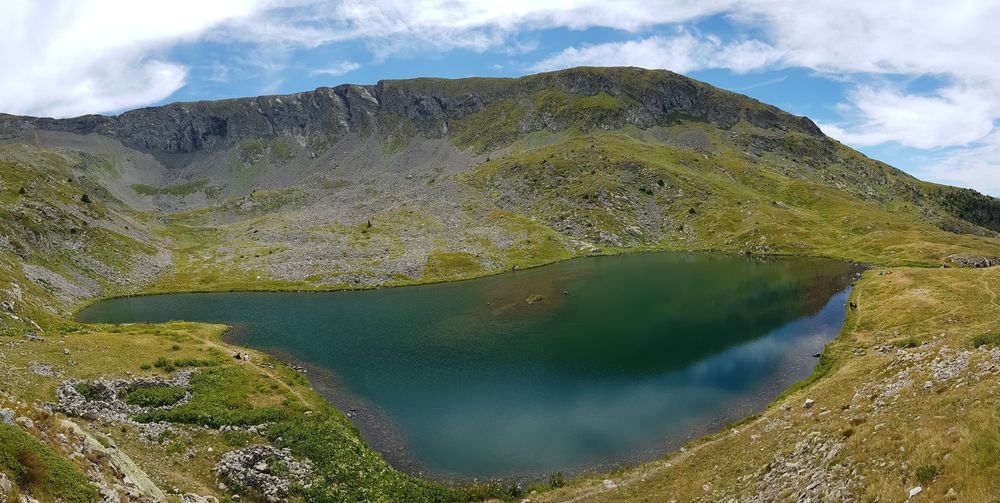
Very nice hike starting from the resort, walk along the waterfall, cross the Louvet Cirque and reach Brouffier lake. Please stay on the main trail, as you enter a very rich but fragile area. Nature deserves being protected.
The characteristics of the route.

Alpe Du Grand Serre (38)
- Distance 8.6 km
- Elevation gain 760 m
- Elevation lost 760 m
- Min. elevation 1364 m
- Max. elevation. 2130 m
- Duration (depending on pace) 5h
- Marking Yes
Start from the Les Mélèzes building. Take the path straight ahead towards the waterfall. At the junction, turn right towards the "Mountain Animals Trail" up to the forest trail.
From there, you will follow the yellow PR markings. Take the track on the right to the “Les Plateaux” crossroads, to start climbing on your left to the “Lac de Prévourey”. Continue to climb on the right, first in the forest then in open ground to the Lac de Brouffier. Passing to the left of the cabin, you will then follow the yellow contour markings to reach the “Brouffier” crossroads and descend towards the “Côte des Salières” and the “Fontenettes”. There, you will take the GR (red and white markings) on the left to reach the Louvet cabin. Pass to the right of the cabin along the forest to join the descent path towards “Bérard”. Continue to descend on the GR, until a well-marked path on your right which leaves the red and white markings and will take you to the Cascade. There, the access track to the site will bring you back to the road. Take the first road on the left, then continue downhill to return quietly to the parking lot opposite the Tourist Office.Opening : All year round daily. Subject to favorable snow and weather conditions.
From there, you will follow the yellow PR markings. Take the track on the right to the “Les Plateaux” crossroads, to start climbing on your left to the “Lac de Prévourey”. Continue to climb on the right, first in the forest then in open ground to the Lac de Brouffier. Passing to the left of the cabin, you will then follow the yellow contour markings to reach the “Brouffier” crossroads and descend towards the “Côte des Salières” and the “Fontenettes”. There, you will take the GR (red and white markings) on the left to reach the Louvet cabin. Pass to the right of the cabin along the forest to join the descent path towards “Bérard”. Continue to descend on the GR, until a well-marked path on your right which leaves the red and white markings and will take you to the Cascade. There, the access track to the site will bring you back to the road. Take the first road on the left, then continue downhill to return quietly to the parking lot opposite the Tourist Office.Opening : All year round daily. Subject to favorable snow and weather conditions.
Area : Matheysine
Report a problem
Website TOPO_Lac de Brouffier depuis la station Features of the application :
- Location and orientation on detailed maps thanks to the GPS of your smartphone
- Description of routes and points of interest on the route
- Photo gallery by route
- Detailed elevation profile
- Route tracking alert to warn you if you stray from the route
- Send predefined messages by SMS to your contacts
- Emergency module: trigger a call or send an emergency SMS in case of problem
- Agenda: access to events organized in the department
- News: find in the application the latest news on the web portal
- Adding achievements
- Add reports in case of problems encountered on the routes
- Share on social networks
Add your time and share your feelings
Services nearby

Alpe du Grand Serre Tourist Office
Alpe Du Grand Serre

Belvédère Olivier Messiaen
Saint-Théoffrey

Romanche Museum
Livet-et-Gavet
Arselle Peatbog (Preserved Natural Area)
Chamrousse

Taillefer Hut
Oulles


Information updated on 2025-08-29 by Matheysine Tourisme


Follow us on
the digital trails
the digital trails


![]()
The Isère Outdoor application was created
by the Département de l'Isère
Infos & contact
Conseil départemental de l'Isère
7 rue Fantin Latour
CS 41096
38 022 Grenoble cedex 1
Tel. 04 76 00 38 38
 Isère Outdoor - Parcours - Brouffier lake, starting from resort
Hello, world! This is a toast message.
Isère Outdoor - Parcours - Brouffier lake, starting from resort
Hello, world! This is a toast message.
Isère Outdoor - Parcours - Brouffier lake, starting from resort
Hello, world! This is a toast message.


OK
Annuler