Chapels and woods of Cessieu
Add to my favorites

This short and shaded loop invites you to contemplate the chapels Notre-Dame de Salette and St-Joseph as well as the beautiful panorama located at the second one.
The characteristics of the route.

Cessieu (38)
- Distance 7.07 km
- Elevation gain 290 m
- Elevation lost 290 m
- Min. elevation 301 m
- Max. elevation. 496 m
- Duration (depending on pace) 2h
- Marking Yes
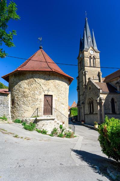
From the Champ de Mars, you will reach the church of Cessieu. Step inside to admire the murals by Dutch artist Cor van Gelenken. Just behind the church stands the round clock tower. It is said to have played a protective role in medieval times.
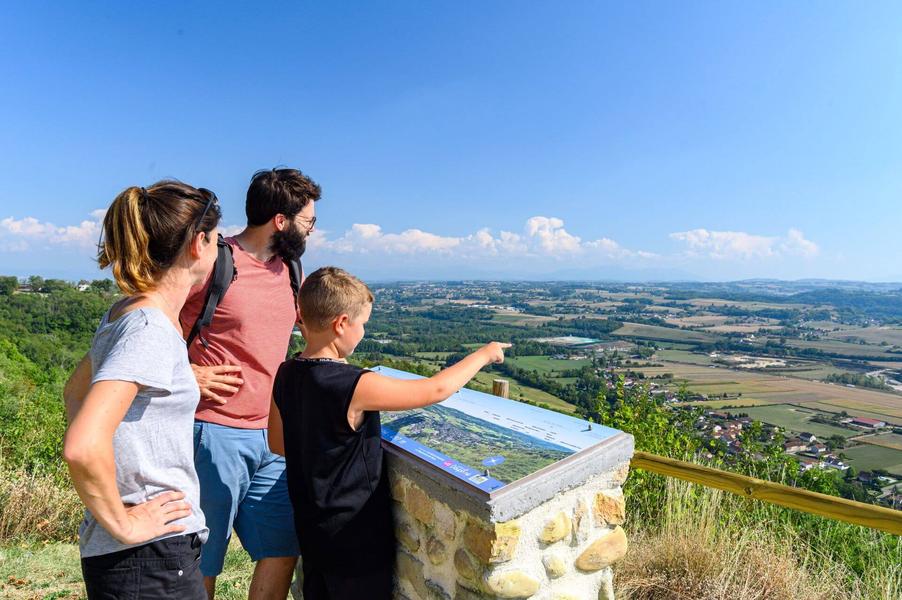
Follow the path up into the forest. After 400m, you'll see the Notre-Dame de Salette chapel on your left. Continue uphill to the St-Joseph chapel. Freshly restored, it overlooks the Bourbre valley.
From the viewpoint indicator behind the chapel, you can contemplate the Monts du Lyonnais, the Vercors and the Chartreuse.
After Croix de Fer, you pass through a number of hamlets and the Cessieu woods. The profile descends to Les Guerres and climbs back up to Les Communaux. The hike ends downhill on a small road lined with hedgerows.
Translated with DeepL.com (free version)
From the parking of the Champ de Mars in Cessieu, follow the yellow markings and the following signposts:
>CESSIEU
>La Croix de Fer
> La Croix de Pierre
>La Croix de Fer
>CESSIEUMarking : From the Champ de Mars parking lot in Cessieu, follow the yellow marks and the following crossroads: >CESSIEU >La Croix de Fer >Montbertaud >Les Guerres >Les Communaux >Champ Robert >CESSIEUEquipments : Public WC, Parking nearby, Delicate passages : The slope between "La Croix de Fer" and "La Croix de Pierre" is quite steep from the Chapelle St-Joseph.Admission fee : Free access.Opening : All year round daily.
Area : Vals du Dauphiné
Report a problem
Website Features of the application :
- Location and orientation on detailed maps thanks to the GPS of your smartphone
- Description of routes and points of interest on the route
- Photo gallery by route
- Detailed elevation profile
- Route tracking alert to warn you if you stray from the route
- Send predefined messages by SMS to your contacts
- Emergency module: trigger a call or send an emergency SMS in case of problem
- Agenda: access to events organized in the department
- News: find in the application the latest news on the web portal
- Adding achievements
- Add reports in case of problems encountered on the routes
- Share on social networks
Vince72
The 2025/09/07
En savoir plus
Ajouter votre chrono et partager vos sensations
2025/09/07 Vince72
2025/09/07 Vince72
Services nearby

Etang de Gôle Sensitive Natural Area
Montcarra

Tourist information office of La Tour du Pin - Office de Tourisme des Vals du Dauphiné
La Tour-du-Pin

Relais Cyné de Chateauvilain
Châteauvilain

Saint-Chef Museum
Saint-Chef
Saint-Chef - Balcons du Dauphine Tourist Information Office
Saint-Chef


Information updated on 2025-08-08 by Office de Tourisme des Vals du Dauphiné


Follow us on
the digital trails
the digital trails


![]()
The Isère Outdoor application was created
by the Département de l'Isère
Infos & contact
Conseil départemental de l'Isère
7 rue Fantin Latour
CS 41096
38 022 Grenoble cedex 1
Tel. 04 76 00 38 38
 Isère Outdoor - Parcours - Chapels and woods of Cessieu
Hello, world! This is a toast message.
Isère Outdoor - Parcours - Chapels and woods of Cessieu
Hello, world! This is a toast message.
Isère Outdoor - Parcours - Chapels and woods of Cessieu
Hello, world! This is a toast message.


OK
Annuler