Prégentil - Hiking from Bourg-d'Oisans
Add to my favorites

Caution! Zone of vigilance near the route
Circaète Jean-le-Blanc - du 01/03/2026 au 30/09/2026 In progress
Pregentil - du 15/05/2026 au 30/10/2026 In progress
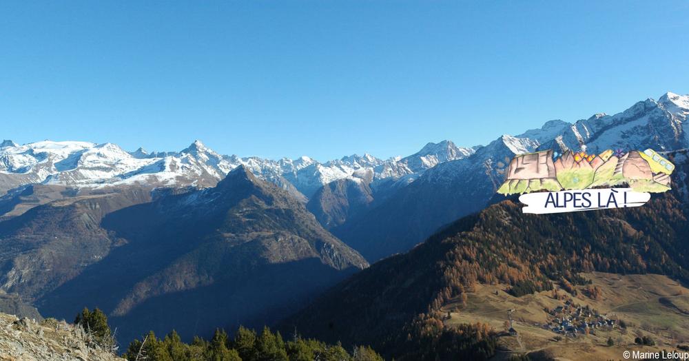
A beautiful route between forests and meadows surrounded by the peaks of the Ecrins.
The characteristics of the route.

Le Bourg-d'Oisans (38)
- Distance 15 km
- Elevation gain 1260 m
- Elevation lost 1260 m
- Min. elevation 718 m
- Max. elevation. 1935 m
- Duration (depending on pace) 6h50
- Marking Yes
TECHNICAL INFORMATION
Departure: Bourg-d'Oisans bus station
Height difference: 1237 m
Round trip time: 6h50 (loop)
Return distance: 14.6 km
Level : Very difficult
ITINERARY
From the bus station, walk 100m towards Bourg d'Oisans town center on the main road (D1091b) to take rue Jean-Baptiste Gauthier (right) and pass the Maison du Parc.
At the crossroads, follow signs for Villard-Reymond, turning right into rue St Antoine, then left into rue "Au-dessus du Bourg" to reach the Merlon.
1) Le Merlon (745 m) - 3 h 10 (4.8 km, D+ 930 m)
After the Salle des Associations, follow a path along the torrent (right bank) without crossing it. Descend a flight of tire steps to cross a merlon (large artificial ditch designed to stop rock falls), then climb into the forest on the hairpin path. Pass the forest hut (alt. 1360 m, simple unenclosed shelter). Follow the signs and arrows (black on yellow).
yellow background). After a meadow, take a wide path to the Col du Solude.
2) Col du Solude (1680 m) - 1 h (2.1 km, D+ 246 m)
[Return trip possible (5 min) to Villard-Reymond].
After enjoying a fine view, take the north-western path leading to the Col de St Jean, just below the north-eastern slope of Prégentil.
Climb to its summit (100 m D+ Orange points).
3) Prégentil (1938 m) - 1 h 45 (4.7 km, D+ 32 m, D- 918 m)
Descend to Col de St Jean, then take the north-west path to cross the Tête des Fromentières meadow. Continue in the direction of Bourg d'Oisans: switch to the forest (heading northeast) and descend via a number of hairpins, first on the west-facing side of the ridge (with an easy cabled passage), then on the east-facing side. The descent continues through the forest on a path that crosses a track at 1270 m, before arriving at the clearing and ruins of Le Puy.
4) Le Puy (1040 m) - 35 min (1.7 km, D- 292 m)
Descend to the point on the south path (right): once down to the Alberts torrent, ford it (go up 5m).
5) Le Merlon (745 m) - 10 min (0.7 km, D- 30 m)
Return to the bus station via the Maison du Parc.
Return to Bourg d'Oisans - Gare Routière (718 m)Marking : This itinerary is marked with yellow PDIPR-type signs.Delicate passages : Portion of ridge route with a cabled passage (no difficulty).Admission fee : Free access.Opening : From 01/05 to 30/09 daily. Subject to favorable snow and weather conditions.Warning : A car-free hike where you can take the bus to and from the site. Make sure you know the time and day of traffic before you leave.
Departure: Bourg-d'Oisans bus station
Height difference: 1237 m
Round trip time: 6h50 (loop)
Return distance: 14.6 km
Level : Very difficult
ITINERARY
From the bus station, walk 100m towards Bourg d'Oisans town center on the main road (D1091b) to take rue Jean-Baptiste Gauthier (right) and pass the Maison du Parc.
At the crossroads, follow signs for Villard-Reymond, turning right into rue St Antoine, then left into rue "Au-dessus du Bourg" to reach the Merlon.
1) Le Merlon (745 m) - 3 h 10 (4.8 km, D+ 930 m)
After the Salle des Associations, follow a path along the torrent (right bank) without crossing it. Descend a flight of tire steps to cross a merlon (large artificial ditch designed to stop rock falls), then climb into the forest on the hairpin path. Pass the forest hut (alt. 1360 m, simple unenclosed shelter). Follow the signs and arrows (black on yellow).
yellow background). After a meadow, take a wide path to the Col du Solude.
2) Col du Solude (1680 m) - 1 h (2.1 km, D+ 246 m)
[Return trip possible (5 min) to Villard-Reymond].
After enjoying a fine view, take the north-western path leading to the Col de St Jean, just below the north-eastern slope of Prégentil.
Climb to its summit (100 m D+ Orange points).
3) Prégentil (1938 m) - 1 h 45 (4.7 km, D+ 32 m, D- 918 m)
Descend to Col de St Jean, then take the north-west path to cross the Tête des Fromentières meadow. Continue in the direction of Bourg d'Oisans: switch to the forest (heading northeast) and descend via a number of hairpins, first on the west-facing side of the ridge (with an easy cabled passage), then on the east-facing side. The descent continues through the forest on a path that crosses a track at 1270 m, before arriving at the clearing and ruins of Le Puy.
4) Le Puy (1040 m) - 35 min (1.7 km, D- 292 m)
Descend to the point on the south path (right): once down to the Alberts torrent, ford it (go up 5m).
5) Le Merlon (745 m) - 10 min (0.7 km, D- 30 m)
Return to the bus station via the Maison du Parc.
Return to Bourg d'Oisans - Gare Routière (718 m)Marking : This itinerary is marked with yellow PDIPR-type signs.Delicate passages : Portion of ridge route with a cabled passage (no difficulty).Admission fee : Free access.Opening : From 01/05 to 30/09 daily. Subject to favorable snow and weather conditions.Warning : A car-free hike where you can take the bus to and from the site. Make sure you know the time and day of traffic before you leave.
Area : Oisans
Report a problem
Website TOPO Prégentil - Hiking from Le Bourg-d'Oisans_Le Bourg-d'Oisans Features of the application :
- Location and orientation on detailed maps thanks to the GPS of your smartphone
- Description of routes and points of interest on the route
- Photo gallery by route
- Detailed elevation profile
- Route tracking alert to warn you if you stray from the route
- Send predefined messages by SMS to your contacts
- Emergency module: trigger a call or send an emergency SMS in case of problem
- Agenda: access to events organized in the department
- News: find in the application the latest news on the web portal
- Adding achievements
- Add reports in case of problems encountered on the routes
- Share on social networks
Add your time and share your feelings
Services nearby

Maison de l'Oisans et du Parc national des Écrins
Le Bourg-d'Oisans

GALTA the Alpine Treasures Gallery
Le Bourg-d'Oisans
Auris-en-Oisans Tourist Office
Auris-en-Oisans
Tourist office of Villard-Reculas
Villard-Reculas
Office de Tourisme
Alpe d'Huez


Information updated on 2025-12-18 by Isère Attractivité


Follow us on
the digital trails
the digital trails





The Isère Outdoor application was created
by the Département de l'Isère
Infos & contact
Conseil départemental de l'Isère
7 rue Fantin Latour
CS 41096
38 022 Grenoble cedex 1
Tel. 04 76 00 38 38
 Isère Outdoor - Parcours - Prégentil - Hiking from Bourg-d'Oisans
Hello, world! This is a toast message.
Isère Outdoor - Parcours - Prégentil - Hiking from Bourg-d'Oisans
Hello, world! This is a toast message.
Isère Outdoor - Parcours - Prégentil - Hiking from Bourg-d'Oisans
Hello, world! This is a toast message.


OK
Annuler