En passant par la Grotte du Loup
Add to my favorites

A nice loop mostly in the forest which bypasses several streams and curiosities. Enjoy the views over the Chartreuse and the villages of Entre-Deux- Guiers and Les Echelles.
The characteristics of the route.

Miribel-les-Échelles (38)
- Distance 4.6 km
- Elevation gain 180 m
- Elevation lost 180 m
- Min. elevation 448 m
- Max. elevation. 606 m
- Duration (depending on pace) 2h
- Marking Yes
Marking : Departure Signs are in place in the villages near the car parks and the places open to the public. To follow your itinerary, poles are in place at the junctions and identifiable by a sign with the name of the walk and the altitude. Between two poles, you will find marked sign made with painting all along the way, it indicates if you must follow the path or not. Pay also attention to small signs to guide you.
We recommend to have the map Promenades et randonnées en Chartreuse" with you.Admission fee : Free of charge.Opening : From 01/05 to 30/11.
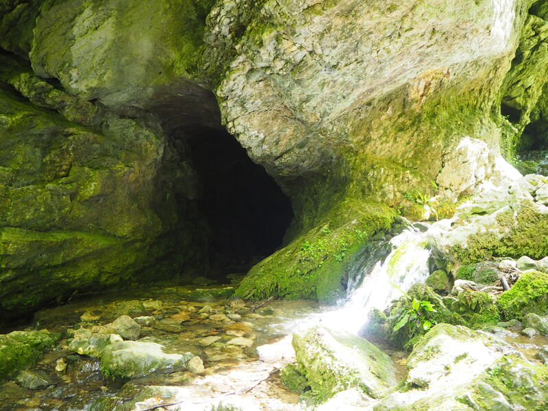
Subject to favorable weather.Step by step description : (1) This round trip starts at the Villar’s car park in the village of Miribel-les-Échelles. On this itinerary, follow the orange signs (local marked path). Follow the direction of Notre-Dame du Château. Pass by the Croix St Maurice, then turn left to La Grotte du Loup. You leave the road for a path, which enters a field with cows. Mind to close all the fences behind you, keep your dog on a leash, and stay on the path. Do not yell and do not make sudden movements. Stay on the path going down in the undergrowth. On your left, you find a first local curiosity: a basin. (2) At the junction, turn left towards La Grotte du Loup. After crossing the stream, on the right by a steep way down, you can go back and forth to the Grotte du Loup. Back on the main path, keep walking in the undergrowth. You pass by the Croix des Combes, perched on its rock. After crossing the stream, go straight ahead on the main path. Cross a bridge. (3) At the fork of La Roche qui Pleure, take the path on the right. Cross another bridge: the Pont des Combes. Stay on the path and enjoy the nice views on the Chartreuse’s peaks (Mount Beauvoir and Mount Outheran) and the countryside. Cross another stream: ruisseau du Chenevas (be careful when you cross, makeshift bridge). The route is going up through open places and in the undergrowth. (4) At the junction turn right: beautiful views on the countryside and the peaks of Chartreuse. At the next fork, Panneau le Chaboud 520m, take the road that goes down on the left and that brings you to the hamlet Sous-le-bois. Cross the hamlet and, (5) at the junction with the Chemin de Pierrafite, take the small path that goes up on the right. After a way up at the edge of the fields you meet the road that brings you back to the Villar’s car park.
Area : Cœur de Chartreuse
Report a problem
Website Pdf file Features of the application :
- Location and orientation on detailed maps thanks to the GPS of your smartphone
- Description of routes and points of interest on the route
- Photo gallery by route
- Detailed elevation profile
- Route tracking alert to warn you if you stray from the route
- Send predefined messages by SMS to your contacts
- Emergency module: trigger a call or send an emergency SMS in case of problem
- Agenda: access to events organized in the department
- News: find in the application the latest news on the web portal
- Adding achievements
- Add reports in case of problems encountered on the routes
- Share on social networks
Add your time and share your feelings
Services nearby

Espace Naturel Sensible des Tourbières de l'Herretang
Saint-Laurent-du-Pont

Coeur de Chartreuse Tourist Information center at Saint Laurent du Pont
Saint-Laurent-du-Pont

Relais Cyné de Montferrat
Montferrat

Pégoud Museum
Montferrat
Museum of la Grande Chartreuse
Saint-Pierre-de-Chartreuse


Information updated on 2024-07-24 by Chartreuse Tourisme


Follow us on
the digital trails
the digital trails


![]()
The Isère Outdoor application was created
by the Département de l'Isère
Infos & contact
Conseil départemental de l'Isère
7 rue Fantin Latour
CS 41096
38 022 Grenoble cedex 1
Tel. 04 76 00 38 38
 Isère Outdoor - Parcours - En passant par la Grotte du Loup
Hello, world! This is a toast message.
Isère Outdoor - Parcours - En passant par la Grotte du Loup
Hello, world! This is a toast message.
Isère Outdoor - Parcours - En passant par la Grotte du Loup
Hello, world! This is a toast message.


OK
Annuler