Le Col des Mille Martyrs
Add to my favorites

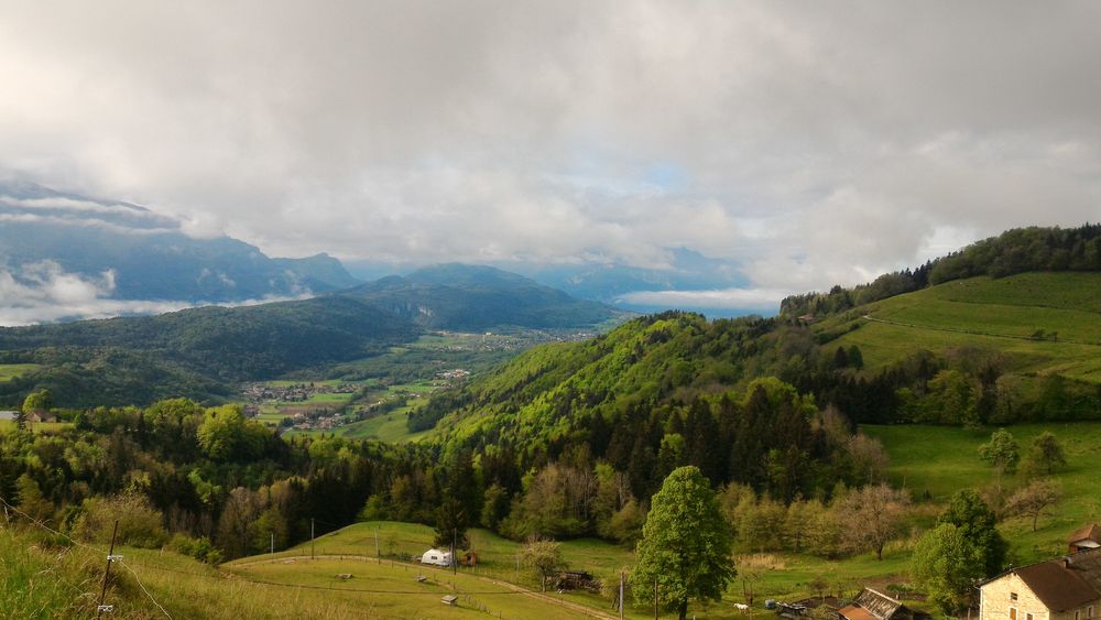
Facing La Grande Sure, this gentle hike offers an exceptional panorama of the Haute Chartreuse, winding through meadows and forests.
Route labeled FFRandonnée

The characteristics of the route.

Miribel-les-Échelles (38)
- Distance 12.5 km
- Elevation gain 380 m
- Elevation lost 380 m
- Min. elevation 585 m
- Max. elevation. 873 m
- Duration (depending on pace) 3h30
- Marking Yes
Nearby Visit Ideas Along the Route:
Plantimay Cheese Farm (9 km from the start): Farm tour.
Atelier du Tilleul (5 km from the start): Visit the last woodturning and tablet-making workshop in Chartreuse.
Chartreux Caves and Distillery (15 km from the start): Tour the world’s largest liqueur cellar.
For more details and additional visit ideas, visit chartreuse-tourisme.com/rsf.
Useful Numbers:
Weather (essential to check before departure): 3250 or www.meteo.fr
Mountain Rescue: 112
Information / Safety:
Follow a few basic rules and tips to ensure a safe and enjoyable hike. Check our recommendations and advice before heading out at chartreuse-tourisme.com/conseils-rando-trail (or request them at tourist offices).
Did you know? Mountain guides are experts in mountain flora and fauna, off-the-beaten-path hikes, local history, and Alpine traditions. They ensure a safe and enriching experience! A detailed list of guides is available at chartreuse-tourisme.com/accomp (or at tourist offices).
Note: You hike under your own responsibility. Chartreuse Tourisme and tourist offices are not liable for the suggested routes.Marking : Starting signs are installed in villages at parking areas or public reception points. To follow your route, posts are placed at intersections, each identified by a plaque showing its name and altitude. Between two posts, painted markers guide you along the path (or indicate paths not to follow). You may also be directed by small wayfinding signs. The "Walks and Hikes in Chartreuse" map is recommended.Admission fee : Free access.Opening : From 01/05 to 30/11. Subject to favorable weather.Step by step description : Starting from Miribel-les-Échelles, head towards Le Villar and follow signs to Til and Croix St Antoine. Continue toward La Mortière to reach the forest and follow it to Croix St Roch. From there, head to Sous Mafray and pass through Col des Mille Martyrs via Bois Carabotin. Return to Miribel via Michallat, crossing the Forêt de Miribel and discovering the Dolmen de l'Antillière and Croix de Tempétat along the way.
Area : Cœur de Chartreuse
Report a problem
Pdf file Features of the application :
- Location and orientation on detailed maps thanks to the GPS of your smartphone
- Description of routes and points of interest on the route
- Photo gallery by route
- Detailed elevation profile
- Route tracking alert to warn you if you stray from the route
- Send predefined messages by SMS to your contacts
- Emergency module: trigger a call or send an emergency SMS in case of problem
- Agenda: access to events organized in the department
- News: find in the application the latest news on the web portal
- Adding achievements
- Add reports in case of problems encountered on the routes
- Share on social networks
Add your time and share your feelings
Services nearby

Espace Naturel Sensible des Tourbières de l'Herretang
Saint-Laurent-du-Pont

Coeur de Chartreuse Tourist Information center at Saint Laurent du Pont
Saint-Laurent-du-Pont

Relais Cyné de Montferrat
Montferrat

Museum of la Grande Chartreuse
Saint-Pierre-de-Chartreuse
Pégoud Museum
Montferrat


Information updated on 2024-10-30 by Chartreuse Tourisme


Follow us on
the digital trails
the digital trails


![]()
The Isère Outdoor application was created
by the Département de l'Isère
Infos & contact
Conseil départemental de l'Isère
7 rue Fantin Latour
CS 41096
38 022 Grenoble cedex 1
Tel. 04 76 00 38 38
 Isère Outdoor - Parcours - Le Col des Mille Martyrs
Hello, world! This is a toast message.
Isère Outdoor - Parcours - Le Col des Mille Martyrs
Hello, world! This is a toast message.
Isère Outdoor - Parcours - Le Col des Mille Martyrs
Hello, world! This is a toast message.


OK
Annuler