The stream of Pissarde
Add to my favorites

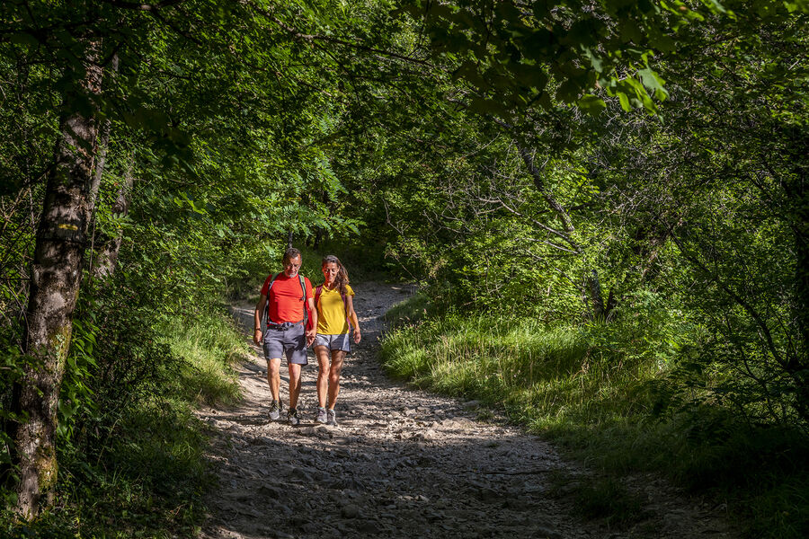
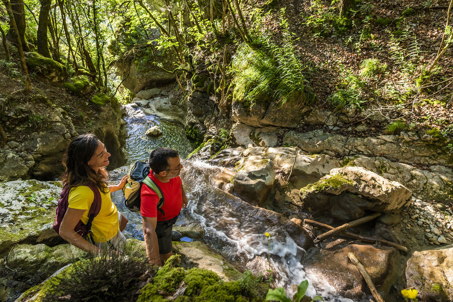
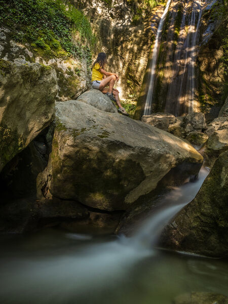
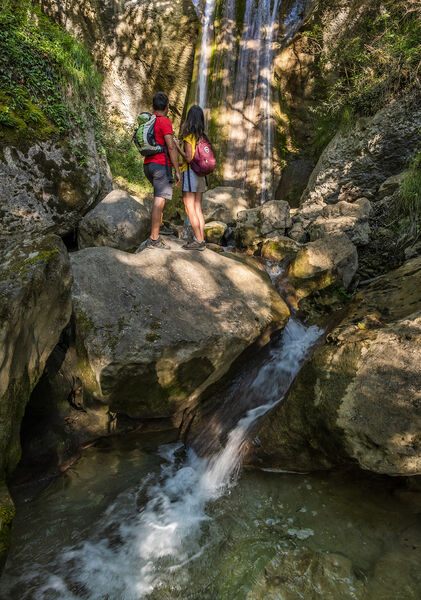
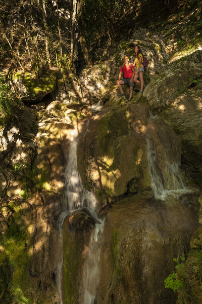
In Claix, at the foot of the Vercors, flows the stream of the Pissarde with its Cascade d'Allières. In summer, you can find a little coolness here. It is however advisable to be careful at the level of the cascades not to approach too close to the verticals.
The characteristics of the route.

Claix (38)
- Distance 11 km
- Elevation gain 830 m
- Elevation lost 830 m
- Min. elevation 341 m
- Max. elevation. 1142 m
- Duration (depending on pace) 5h
- Marking Yes
Marking : Yellow markingsAdmission fee : Free access.Opening : All year round.Step by step description : From the Château d'Allières (alt. 350 m), return to the road on the Claix side, heading for Allières at 80 m. Follow the yellow markings on this hike. After a few hundred metres, the signposted itinerary turns left into "rue du Pré du Merle" towards Savoyères and La Pissarde. You walk up the street, then the tarmac gives way to a dirt track which you take straight ahead to find the road a little further up. After another 50 m, you leave the road again. Keep heading for La Pissarde. The path then rises more steeply for around 200 m of ascent. Just as you reach the asphalt again, turn left, passing the right-hand bend by approx. 100 m. The path takes you back to the left-hand side of the road, and a little further up the left bank of the Pissarde stream. The path takes you back to a road at the combe du Vent (alt. 735 m). Continue straight ahead along the path towards Savoyères, with La Pissarde still on your left. The route eventually turns away from the stream to the north, and after a flight of steps, reaches another, wider path which you continue upstream. This brings you to the hamlet of Savoyères (alt. 862 m). Without taking the road, turn directly left. On the building in front of you, a sign points the way to Saint-Auge and Col de l'Arc. (Please note: Malatrat is not indicated on the Savoyères PDIPR sign). At the next signpost, follow signs for Malatrat. To get there, turn right towards the Combe de la Paillière. Always follow the yellow markings, and above the water reservoir, go straight ahead in the bend and not the track on the right, which you'll find again further up to the left.
At the combe de la Paillière (alt. 1,067 m), continue straight ahead to reach the combe du Cerisier (alt. 1,131 m), the high point of your hike. Turn left onto the wide forest track, descending towards Bois de la Pissarde. At Bois de la Pissarde (alt. 1,100 m), back on a road, continue downhill towards Biaucoin and Savoyères. At Biaucoin (alt. 1,040 m), turn left off the asphalt. This main track takes you to Malatrat, where you join your loop. Just turn right to reach Savoyères. At Savoyères (alt. 862 m), turn right again to go downhill along your route to your starting point at Château d'Allières (alt. 350 m).
Points of interest :
- Allières waterfall
- La Pissarde stream
- Savoyères
- Cool undergrowth
Area : Grenoble-Alpes Métropole
Report a problem
Website Pdf file Features of the application :
- Location and orientation on detailed maps thanks to the GPS of your smartphone
- Description of routes and points of interest on the route
- Photo gallery by route
- Detailed elevation profile
- Route tracking alert to warn you if you stray from the route
- Send predefined messages by SMS to your contacts
- Emergency module: trigger a call or send an emergency SMS in case of problem
- Agenda: access to events organized in the department
- News: find in the application the latest news on the web portal
- Adding achievements
- Add reports in case of problems encountered on the routes
- Share on social networks
Add your time and share your feelings
Services nearby

Espace naturel sensible de la tourbière du Peuil
Claix

Espace Histo Bus Dauphinois
Le Pont-de-Claix

Auberge des Allières
Lans-en-Vercors
Musée Autrefois
Champ-sur-Drac
Musée Géo-Charles
Échirolles


Information updated on 2025-05-06 by Office de Tourisme Grenoble Alpes


Follow us on
the digital trails
the digital trails


![]()
The Isère Outdoor application was created
by the Département de l'Isère
Infos & contact
Conseil départemental de l'Isère
7 rue Fantin Latour
CS 41096
38 022 Grenoble cedex 1
Tel. 04 76 00 38 38
 Isère Outdoor - Parcours - The stream of Pissarde
Hello, world! This is a toast message.
Isère Outdoor - Parcours - The stream of Pissarde
Hello, world! This is a toast message.
Isère Outdoor - Parcours - The stream of Pissarde
Hello, world! This is a toast message.


OK
Annuler